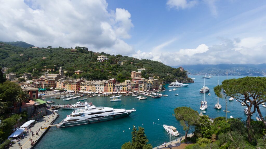
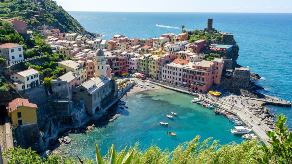
• 0039 0185 286531
  • Hotel Annabella - Via Costasecca 10/1 - 16038 Santa Margherita Ligura (GE) - Italia

Around us

Portofino

The municipality is located in the western part of the Gulf of Tigullio, in a bay at the foot of the headland of the same name, east of Genoa, effectively marking the geographical boundary between the Paradise Gulf and tigullio.

The entire town area is included in the Portofino Regional Nature Park and the Portofino Protected Marine Natural Area.

The best way to appreciate the wonders of the park is to safely walk its most characteristic and fascinating paths, all properly marked. Crossing the dense network of more than 60 km, you can discover the richness and variety of natural environments, landscapes and complex monuments of the headland.

Sestri Levante

The territory of Sestri Levante is located on the Ligurian Riviera of the east, and precisely it is one of the last resorts that face east on the Gulf of Tigullio, east of Genoa.

It rises on the floodplain of the Gromolo stream, close to a rocky headland, usually called “the island”, stretched out to the sea, and joined to the mainland by an isthmus that divides the “Bay of Fairy Tales”, where the marina was obtained and whose Name was attributed by the writer Hans Christian Andersen (who stayed at Sestri Levante in 1833), by the smaller but even more evocative “Bay of Silence”.

Another barrier before the beaches of the hamlet of Riva Trigoso, which continue to the town of Borgo Renà, is the headland of Punta Manara and Monte Castello (265 m). In the town of Rena stands the characteristic rock of the “Assau”, topped by a cross, and further east are Baffe and Mount Moneglia (521 m) that hide the view of Vallegrande and the territory of Moneglia.

Between the two bays and the isthmour develops the old town, while the most modern part occupies the plain that, extending between the sea and the hills of the hinterland, divides Sestri Levante to the north from the Graveglia valley with Mont Blanc, 876 m high, and to the northeast from the Val Petronio with the Mount Caddio (390 m), Mount Bomba (608 m) and Mount Incisa (700 m); to the north-west the headland of Sant’Anna continues for a difficult but scenic and scenic ridge on the Gulf of Tigullio, up to the mountains Costello (498 m), Zucchetto (614 m) and Capenardo (693 m).

Chiavari

The city overlooks the Ligurian Sea of the Levant Riviera, geographically located in the center of the Gulf of Tigullio, east of Genoa.

The urban core is located to the right of the Entella River, which here flows at the end of the floodplain, dividing the city to the east from the adjacent Lavagna; The city is also crossed by the Rupinaro stream in the westernmost part of the municipality and other minor rii.

Cinque Terre

Thanks to the geographical and anthropogenic characteristics of the territory where they arise, the Cinque Terre are considered one of the most evocative Italian coastal attractions, for their naturally rugged and rugged hilly orographic context, softened by the construction of terraces or bands for the crop, which descends towards the sea with steep slopes; in the places where the sea creeps serpentine lychee into the land rise the villages, set to follow the natural shape of the hills.

The work of man, over the centuries, has shaped the territory by building the famous terraces on the slopes at sea, due to the particular agricultural technique aimed at exploiting as much as possible the land placed in steep slopes that slopes towards the sea, has made it one of the most characteristic and fascinating landscapes of Liguria.

In 1997, at the request of the province of Spezia, the Cinque Terre, together with Porto Venus and the islands Palmaria, Tino and Tinetto, were included among the World Heritage Sites by Unesco. In 1998, the Ministry of the Environment established the Cinque Terre Marine Protected Area for environmental protection, protection and enhancement of biological resources, for the dissemination and promotion of a socio-economic development compatible with the natural-landscape relevance of the area. In 1999 the Cinque Terre National Park was established for the preservation of ecological balances, the protection of the landscape, the preservation of the anthropological values of the place.

The Cinque Terre were part of the mountain community of the Broken Riviera. On 25 October 2011, a violent flood and subsequent landslides led to the death of at least 7 people. The municipalities most affected are Monterosso al Mare and Vernazza. On September 24, 2012, a landslide caused by the detachment of a rock ridge overwhelms four Australian tourists on the Way of Love. After the landslide, the trail remained closed until April 3, 2015, when the first section was reopened.

Rapallo

Rapallo is located in the western part of the Gulf of Tigullio, nestled in the gulfthat takes its name (historically called “Gulf of the Griffin” ), between the plain of the two Boate streams – historically called “Bogo” – and St. Francis, the latter in the eastern part of the city. The municipality is also crossed by numerous waterways and minor rii (among the main ones the St. Peter, the St. Mary, the Sellano, the Cereghetta, the Carcara) where, over the centuries, housing units corresponding to today’s hamlets and rapacious locations.

Reached by special trails, there are among the main peaks of the territory the Handle of the Lume (801 m, the highest point of Rapallo and the geographical area of West Tigullio-Golfo Paradiso), Mount Pegge (774 m, where the margherita hut is located), the Mount Lasagna (728 m), Mount Bello (713 m), Mount Rosa (692 m), Mount Orsena or Caravaggio (615 m, home to the Marian shrine of the same name), Mount Ampola (580 m) and Mount Of Pools (528 m). At 612 m high sea level is, near Mount Letho, the sanctuary of Our Lady of Montallegro.